New DNA evidence reveals the rich prehistoric world of Doggerland, the vanished land that once linked Britain to mainland Europe

For thousands of years, long before waves rolled across the North Sea, a vast stretch of land connected what is now Britain with continental Europe. Known today as Doggerland, this forgotten landscape was once a thriving ecosystem of forests, rivers, wetlands, and wildlife.
Now, new genetic research is helping scientists reconstruct this “sunken world” with unprecedented detail—revealing that it may have supported vibrant Stone Age communities whose traces now lie buried beneath the seabed.
The emerging picture is reshaping how archaeologists understand early human life in northern Europe.
A Landscape Lost to the Sea
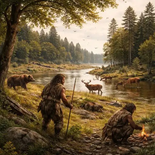
Doggerland once formed a broad plain between Britain and present-day Denmark, the Netherlands, and Germany. Rather than the open water that exists today, the region would have looked more like a rich lowland wilderness.
Researchers describe a landscape filled with oak forests, marshlands, winding rivers, and freshwater lakes, a habitat capable of supporting large mammals and human populations alike.
Herds of deer likely moved through the woods, while wild boar rooted in the undergrowth. Bears and other predators roamed the forest edges, and wetlands teemed with birds and fish.
For prehistoric hunter-gatherers, it would have been an ideal home.
“This was not an empty land bridge,” scientists explain. “It was a living landscape, full of resources and ecological diversity.”
DNA From the Seafloor
The most recent breakthrough comes from a technique known as environmental DNA analysis, which allows scientists to identify traces of plants and animals from sediment samples.
Researchers have begun extracting genetic fragments preserved in ancient mud collected from the North Sea floor. These microscopic clues provide a record of life that once thrived on the now-submerged land.
The results confirm the presence of a wide range of species, including red deer and elk, wild boar, brown bears, woodland plants and shrubs, and freshwater organisms from rivers and lakes.
Together, these findings support the idea that Doggerland was once heavily forested and ecologically rich.
The genetic evidence complements earlier discoveries made by fishermen and dredging operations, which have occasionally brought up prehistoric bones, tools, and fragments of ancient landscapes.
A Hidden Human World
Perhaps the most compelling aspect of Doggerland is the growing belief that it once supported entire human communities.
Stone Age people are thought to have lived there for generations, hunting animals, gathering plants, and traveling along rivers that crisscrossed the land.
Archaeologists suspect the region may have contained camps, seasonal settlements, and possibly larger communities. But unlike sites on land, these settlements are now extremely difficult to locate.
Everything lies beneath layers of sand and seawater.
Still, clues keep appearing. Fishing trawlers have recovered prehistoric tools and bones from the seabed. Mammoth remains and ancient antlers have surfaced in fishing nets. Each discovery strengthens the case that Doggerland was once densely inhabited.
Some scientists believe it may have been one of the most important human landscapes in prehistoric northern Europe.
The Slow Drowning of a Continent
Doggerland did not disappear overnight.
As the climate warmed after the last Ice Age, melting glaciers caused sea levels to rise. Slowly but relentlessly, the sea began to encroach on the low-lying plains.
Rivers became estuaries. Wetlands expanded. Eventually, the rising water cut Britain off from mainland Europe, turning it into an island.
In some places, the transformation may have been gradual enough for human communities to migrate away. In others, sudden flooding or coastal collapse could have reshaped the landscape within generations.
The result was one of the most dramatic geographic changes in European prehistory.
Mapping a Lost Landscape
Today, scientists are combining several technologies to reconstruct Doggerland.
High-resolution sonar mapping, seismic imaging used by offshore energy companies, and sediment sampling are helping researchers visualize the ancient terrain beneath the sea.
These methods reveal the outlines of long-vanished rivers, hills, and valleys—essentially a hidden map of a prehistoric continent.
With each new dataset, Doggerland becomes clearer.
“We’re beginning to see the skeleton of the landscape,” researchers say. “It’s like uncovering a world that has been sealed away.”
Why Doggerland Matters
The rediscovery of Doggerland is more than an archaeological curiosity. It offers a rare glimpse into how humans adapted to dramatic environmental change.
As seas rose and ecosystems shifted, prehistoric communities were forced to move, reorganize, and survive in new territories.
Understanding that process may offer insights into humanity’s resilience in the face of environmental transformation.
It also reminds us that entire chapters of human history can disappear beneath the waves.
Beneath the North Sea, under hundreds of feet of water and sediment, lies the memory of forests, animals, rivers—and perhaps thousands of forgotten lives.
Doggerland may be gone, but thanks to modern science, the lost world connecting Britain and Europe is slowly emerging again from the depths.