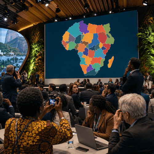
The State Department said it accepted responsibility after a U.S. government slide shown in Brazil mislabeled African countries, triggering criticism over accuracy, diplomacy and the use of AI-generated material.

RIO DE JANEIRO — A U.S. State Department presentation at the AIDS 2026 conference in Brazil drew international criticism after a map of Africa displayed during the session mislabeled countries across the continent, turning a discussion on health assistance into a diplomatic embarrassment.
The erroneous chart was shown during a State Department event linked to U.S. HIV programming and was quickly photographed by attendees before spreading widely online. According to Reuters, the map misplaced multiple countries, including presenting Nigeria as landlocked in the Sahara, shifting Mozambique toward the Horn of Africa and moving Ivory Coast to the wrong side of the continent.
The State Department said the mistake resulted from last-minute changes made by a team member and accepted responsibility for the confusion caused to participants, including African partners. The episode was especially sensitive because the presentation concerned U.S. engagement with countries that have long been central to the global HIV and AIDS response.
The speaker at the session was Jeff Graham, the senior U.S. health envoy overseeing the President’s Emergency Plan for AIDS Relief, known as PEPFAR. The program, launched under President George W. Bush, remains one of Washington’s most prominent global health initiatives and has played a major role in HIV treatment, prevention and health-system support across Africa.
AIDS 2026, the 26th International AIDS Conference, is taking place in Rio de Janeiro and virtually from July 26 to 31. The International AIDS Society describes it as the world’s largest gathering of people living with, affected by and working on HIV, making the setting particularly high-profile for any official presentation by a major donor government.
The mistake also intensified scrutiny of how government agencies use artificial intelligence and automated design tools in official materials. Reports said the slide appeared to contain an OpenAI watermark, raising questions about whether the map had been generated or edited with AI before being included in a diplomatic presentation.
For critics, the incident was not merely a technical error. The inaccurate map appeared in a forum dedicated to health cooperation with many of the same African countries affected by U.S. HIV policy. At a time when aid recipients and public-health advocates are already concerned about changes to U.S. foreign assistance, the image was seen by some attendees as a symbol of carelessness in a relationship that depends heavily on trust and local knowledge.
The State Department emphasized that the broader discussions at the conference remained substantive and reaffirmed U.S. commitment to fighting AIDS through PEPFAR. But the visual error risked undermining that message, particularly because maps are often interpreted as basic indicators of institutional preparation and respect for partner countries.
The controversy comes during a period of uncertainty for U.S. global health policy. Earlier changes and funding disruptions have prompted warnings from advocates that interruptions to HIV programs could damage years of progress. A widely respected program such as PEPFAR depends not only on money and medicine, but also on credibility with governments, clinicians and communities.
While the department’s apology may limit the immediate fallout, the episode is likely to remain a cautionary example for public institutions using AI-assisted tools. In diplomatic settings, a single inaccurate image can travel faster than the policy message it was meant to support.
For Washington, the damage may be reputational rather than operational. But at a global health conference built around partnership, precision and trust, a mislabeled map of Africa became an avoidable symbol of the very distance that diplomacy is supposed to close.