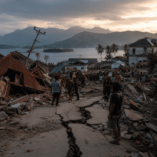
At least 47 people have been killed after a powerful shallow earthquake struck near Flores, triggering tsunami warnings, landslides and widespread destruction as rescuers struggle to reach isolated communities.

A powerful 7.7-magnitude earthquake struck eastern Indonesia early on Saturday, August 15, killing at least 47 people and leaving a trail of destruction across parts of Flores and the surrounding region, as emergency crews raced to reach communities cut off by landslides, damaged roads and communications failures.
The earthquake struck off the northern coast of Flores in East Nusa Tenggara, one of Indonesia’s most seismically vulnerable regions. The United States Geological Survey placed the epicentre about 68 kilometres north-northwest of Ende and estimated the quake at a depth of roughly 10 kilometres. Its relatively shallow depth amplified the intensity of the shaking experienced across the region.
The tremor sent residents rushing from their homes before dawn and prompted thousands of people in coastal communities to move toward higher ground amid fears that a destructive tsunami could follow. Indonesian authorities issued tsunami warnings for several areas before later lifting them after monitoring indicated that the risk of a major wave had diminished. Smaller tsunami waves were nevertheless recorded, with the highest reported at approximately 1.6 metres in the village of Riung.
By Saturday, Indonesia’s National Disaster Mitigation Agency, known as BNPB, reported at least 47 deaths, with further casualties feared as rescue teams attempted to reach remote districts. Thousands of residents have been displaced, while injured people are being treated amid damage to hospitals and other medical infrastructure.
Some of the most serious destruction has been reported in areas including Nagekeo and Maumere. Homes have collapsed or suffered structural damage, while schools, government buildings, religious facilities and health centres have also been affected. Authorities reported hundreds of damaged residential properties and more than 100 affected public facilities.
The mountainous geography of Flores has complicated the emergency response. Landslides triggered by the earthquake blocked sections of the Trans-Flores highway and other roads, while electricity outages and disrupted telecommunications have made it difficult to determine the condition of some villages. Rescue teams have been preparing helicopters, aircraft and maritime transport to reach areas inaccessible by road.
Authorities have also warned residents to remain alert as a prolonged sequence of aftershocks continues to shake the region. More than 230 aftershocks had been recorded following the main earthquake, including a tremor of around magnitude 6.1, raising fears of further building collapses and landslides in already weakened areas.
For survivors, the possibility of another major tremor has added to the uncertainty. Many residents have remained outside damaged buildings or in temporary evacuation centres rather than returning home, even after the tsunami warning was cancelled.
Indonesia is particularly exposed to earthquakes because it lies along the Pacific “Ring of Fire”, a vast zone where several tectonic plates meet and where seismic and volcanic activity is unusually intense. The archipelago has repeatedly endured devastating earthquakes and tsunamis, including the 2004 Indian Ocean disaster and the earthquake and tsunami that struck Sulawesi in 2018.
Flores itself has a history of destructive seismic events. A major earthquake and tsunami struck the island in 1992, killing more than 2,000 people and leaving coastal communities acutely aware of the danger posed by sudden movements of the seabed.
That memory helps explain the rapid movement toward higher ground following Saturday’s earthquake. Even before authorities could fully assess the tsunami threat, residents in vulnerable coastal settlements abandoned low-lying areas, reflecting the lessons learned from decades of natural disasters across the Indonesian archipelago.
The immediate priority is now the search for survivors. Emergency teams are clearing roads, assessing damaged buildings and distributing essential supplies while officials attempt to establish the full scale of casualties and destruction.
The death toll could still change as rescue workers gain access to isolated communities. The combination of collapsed buildings, landslides, disrupted infrastructure and continuing aftershocks means the humanitarian consequences may not become fully apparent until emergency teams reach the hardest-hit parts of Flores.
For Indonesia, Saturday’s disaster is another stark reminder of the permanent geological risks facing a country of more than 17,000 islands situated across some of the most active tectonic boundaries on Earth. The tsunami danger may have receded, but across eastern Indonesia the emergency is far from over.